mlebanon
Originally uploaded by Jane Rubio.
I should have put this up a long time ago.
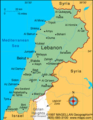
I was in Aley. Spelled 'Alayh on this map. It's 17 km. southeast of Beirut on the major Beirut-Damascus highway. See Baabda about halfway between Aley and Beirut. Baabda is where the Presidential Palace is and a lot of army and government offices.
During the war, the Israelis and Syrians invaded through this highway.
Notice, Tyre and Sidon are cities in the south. See Marjayun in the southeast, where Rola and Ali were. The South was occupied by Israel in the 90's until 2000. They ran a prison called Khiam. (I mentioned before that I went there and you read about at the bottom of the July 2005 archive). It is not Hizbollah-land.
See Rashaya, north of that, that's where Lida is, in the Bekaa Valley. When I talked to her yesterday, she said she heard the bombs. She's so scared. Nothing ever happens there. The South and the Bekaa are mostly Shia areas. But Rashaya is a Druze village.
And north of the that, more to the west is Beyt ad Din, close to Baaqline, the center of the Chouf. This is the center and capital of the Druze. Lama called me from there yesterday, too. In one scenario, I had been planning on hiding out with her there in her villa. (Christine went there with me when she visited last year.) Because the Shouf was always safe during the war. But she was freaked out yesterday, because bombs went off at the southern edge of the Shouf.
I heard they bombed the World Heritage Site of Baalback, the largest surviving Roman temple in the world. Far grander than the Parthenon in Athens. I hope that isn't true. I went there a couple months ago on a field trip with the kids.
Places can be characterized as Christian, Druze, Shia, and Sunni. Aley is Druze. You can go to the Archives of this blog, December 2004, to read about the Druze.
No comments:
Post a Comment